Hurricane Ida Advisory #10

As of 1900 EDT 28 AUG 2021 the Hurricane Watch Net is active on 7.268 MHz. Amateur radio operators are encouraged to monitor this frequency as well as 14.325 MHz during daylight hours. Please DO NOT transmit on these frequencies unless specifically instructed to do so by net control.

BULLETIN
Hurricane Ida Advisory Number 10
NWS National Hurricane Center Miami FL AL092021
400 PM CDT Sat Aug 28 2021

...IDA RAPIDLY STRENGTHENING OVER THE GULF OF MEXICO...
...LIFE-THREATENING STORM SURGE, POTENTIALLY CATASTROPHIC WIND
DAMAGE, AND FLOODING RAINFALL EXPECTED TO IMPACT THE NORTHERN GULF
COAST BEGINNING SUNDAY...


SUMMARY OF 400 PM CDT...2100 UTC...INFORMATION
----------------------------------------------
LOCATION...26.2N 87.0W
ABOUT 240 MI...385 KM SSE OF THE MOUTH OF THE MISSISSIPPI RIVER
ABOUT 325 MI...525 KM SE OF HOUMA LOUISIANA
MAXIMUM SUSTAINED WINDS...105 MPH...165 KM/H
PRESENT MOVEMENT...NW OR 320 DEGREES AT 16 MPH...26 KM/H
MINIMUM CENTRAL PRESSURE...976 MB...28.82 INCHES


WATCHES AND WARNINGS
--------------------
CHANGES WITH THIS ADVISORY:

The Storm Surge Warning has been extended eastward to the
Alabama/Florida border, including Mobile Bay.

SUMMARY OF WATCHES AND WARNINGS IN EFFECT:

A Storm Surge Warning is in effect for...
* East of Rockefeller Wildlife Refuge Louisiana to the
Alabama/Florida border
* Vermilion Bay, Lake Borgne, Lake Pontchartrain, Lake Maurepas,
and Mobile Bay

A Hurricane Warning is in effect for...
* Intracoastal City Louisiana to the Mouth of the Pearl River
* Lake Pontchartrain, Lake Maurepas, and Metropolitan New Orleans

A Tropical Storm Warning is in effect for...
* Cameron Louisiana to west of Intracoastal City Louisiana
* Mouth of the Pearl River to the Alabama/Florida border
Posted in General | Tagged , , , , , , , | Leave a comment

Hurricane Ida Advisory #9

As of 1400 EDT 28 AUG 2018 Hurricane Ida has intensified to category 2 with 100MPH sustained winds. The Hurricane Watch Net will activate at 1600 EDT 28 AUG 2021 on 14.325 MHz and 7.268 MHz. All ClayARES stations are encouraged to monitor these frequencies, but avoid transmission unless specifically requested by net control.

More information is available directly from the Hurricane Watch Net at www.hwn.org.

000
WTNT34 KNHC 281750
TCPAT4

BULLETIN
HURRICANE IDA INTERMEDIATE ADVISORY NUMBER 9A
NWS NATIONAL HURRICANE CENTER MIAMI FL       AL092021
100 PM CDT SAT AUG 28 2021

...IDA INTENSIFYING OVER THE GULF OF MEXICO...
...PREPARATIONS TO PROTECT LIFE AND PROPERTY SHOULD BE RUSHED TO
COMPLETION TODAY IN THE WARNING AREA ALONG THE NORTHERN GULF
COAST...


SUMMARY OF 100 PM CDT...1800 UTC...INFORMATION
----------------------------------------------
LOCATION...25.5N 86.6W
ABOUT 290 MI...470 KM SSE OF THE MOUTH OF THE MISSISSIPPI RIVER
ABOUT 380 MI...610 KM SE OF HOUMA LOUISIANA
MAXIMUM SUSTAINED WINDS...100 MPH...155 KM/H
PRESENT MOVEMENT...NW OR 315 DEGREES AT 16 MPH...26 KM/H
MINIMUM CENTRAL PRESSURE...976 MB...28.82 INCHES

Posted in General | Tagged , | Leave a comment

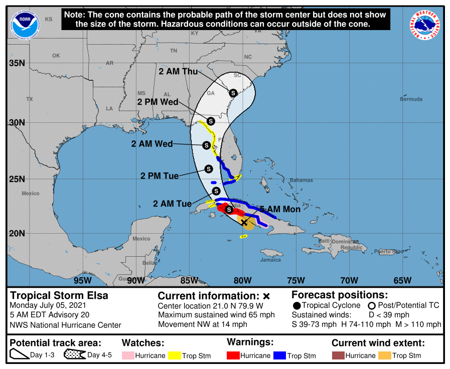
TS Elsa Update 05 JUL 2021 17:00

000
WTUS82 KJAX 052128
HLSJAX
FLZ020-021-023-024-030-031-033-035-038-122-124-125-132-133-136>138-140-222-225-232-236-237-240-325-340-425-GAZ162-163-350-364-060530-
TROPICAL STORM ELSA LOCAL STATEMENT ADVISORY NUMBER 22
NATIONAL WEATHER SERVICE JACKSONVILLE FL  AL052021
528 PM EDT MON JUL 5 2021
THIS PRODUCT COVERS NORTHEAST FLORIDA AND SOUTHEAST GEORGIA
**TROPICAL STORM WATCHES EXPANDED ACROSS THE SUWANNEE RIVER VALLEY AND INTO INLAND PORTIONS OF SOUTHEAST GEORGIA** 
Continue reading
Posted in SKYWARN | Tagged | Leave a comment

TS Elsa Update 07-05-21

Tropical Storm Elsa 

• The center of Elsa is about 225 miles south-southeast of Key West, FL and moving to the northwest at 14 mph

• Elsa remains a tropical storm with maximum sustained winds near 65 mph.

• Elsa is expected to traverse Cuba today and experience some weakening. Late tonight, Elsa will move back over water and head north over the eastern Gulf of Mexico. Little change in strength or some slight re-strengthening is possible after it emerges into the Gulf of Mexico.

• Landfall appears most likely in the eastern Big Bend of Florida. However, the storm will be lopsided with most of the rainfall to the east of the center impacting the entire West Coast as Elsa moves northward.

Florida Outlook:

• Do not focus on the exact forecast points as impacts will extend well outside of the forecast cone.

• Tropical Storm Warnings: Lower and Middle Keys (Dry Tortugas to Craig Key), Mainland Monroe, and coastal portions of Charlotte, Collier, and Lee

• Tropical Storm Watches: Upper Keys (Craig Key to Ocean Reef), Inland portions of Charlotte and Lee, and Citrus, Dixie, Hernando, Hillsborough, Lafayette, Lake, Levy, Manatee, Pasco, Pinellas, Sarasota, Sumter, and Taylor

• Tropical storm force winds from 40-60 mph are possible, particularly in gusts with bands of showers/thunderstorms on Tuesday and Wednesday.

• Storm Surge Watches: Bonita Beach to the Anclote River, or the coastal areas of Charlotte, Citrus, Hernando, Hillsborough, Lee, Levy, Manatee, Pasco, Pinellas, and Sarasota County.

• Storm Surge values of 2-4’ are forecast in the watch area. Storm surge values of 1-2’ are expected across the Keys and Collier County.

• A widespread 3-5” of rain is possible across the eastern Big Bend, Northeast Florida, and West Coast over the next 3 days with localized totals of 6-8”. This could result in some urban or flash flooding early next week due to wet/saturated soils as well as some minor river flooding. Flood Watches may be needed.

• Saturated soils will make trees more susceptible to falling in strong winds.

• Dangerous rip currents are expected at most Florida beaches. Minor to moderate beach erosion is also possible along West Coast beaches with dune overwash.

• There is a threat of isolated tornadoes beginning this afternoon in South Florida and the Keys, spreading up the Peninsula through Tuesday.


NHC
Posted in SKYWARN | Tagged | Leave a comment

TS Elsa Update

National Weather Service Jacksonville has updated our daily weather briefing to highlight potential impacts from Tropical Storm Elsa: https://www.weather.gov/media/jax/briefings/nws-jax-briefing.pdf

Continue reading
Posted in SKYWARN | Tagged | Leave a comment